
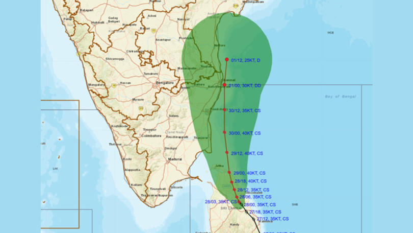

The IMD announced on Friday that Cyclone Ditwah is now moving toward north Tamil Nadu, Puducherry and south Andhra Pradesh. The agency shared the latest update on X and said the storm sits 480 km south-southeast of Puducherry and 580 km south-southeast of Chennai.
The IMD said the storm moved northwest at 8 kmph in the last six hours. It confirmed that the system was centred at 11:30 pm on November 27 near latitude 7.9°N and longitude 81.3°E. It currently lies close to several Sri Lankan cities, including Batticaloa and Trincomalee.
Cyclonic Storm Ditwah [Pronunciation: Ditwah] over coastal Sri Lanka & adjoining southwestBay of Bengal: Cyclone Alert for north Tamil Nadu & Puducherry andadjoining south Andhra Pradesh coasts (Orange Message)
— India Meteorological Department (@Indiametdept) November 28, 2025
The Cyclonic Storm Ditwah [Pronunciation: Ditwah] over coastalSri… pic.twitter.com/5tws6Xm4F5
Cyclone path and impact
The IMD said Cyclone Ditwah will continue to move north-northwest across the Sri Lankan coast and the southwest Bay of Bengal. It will likely reach the waters near north Tamil Nadu, Puducherry and south Andhra Pradesh by the morning of November 30. As a result, the agency warned of strong winds, heavy rainfall and dangerous sea conditions along the coast.
Tamil Nadu issues red alert
RMC Director B. Amudha said the storm will not intensify into a severe cyclonic storm. "It (Ditwah) is currently being treated as a cyclonic storm. Forecasts do not, at present, upgrade it to a severe cyclone," she said, according to PTI.
Therefore, the RMC issued a red alert for four Cauvery Delta districts — Thanjavur, Tiruvarur, Nagapattinam and Mayiladuthurai — until November 30. It also issued an orange alert for Chennai, Tiruvallur, Kancheepuram, Ranipet and Chengalpattu.
A red alert signals extremely heavy rain of more than 20 cm in 24 hours. An orange alert means very heavy rain of 11–20 cm.
Amudha said winds near the storm centre may touch 60–80 kmph and gust up to 90 kmph. She added that the outer bands may see winds of 35–45 kmph, with gusts up to 55 kmph.
She also warned that “similar squally winds of 35–45 kmph, with gusts up to 55 kmph, are also expected over parts of the Arabian Sea adjoining Kerala, Lakshadweep and Maldives.”
Coastal warnings and precautions
The IMD urged fishermen to avoid the south, central, southwest and southeast Bay of Bengal for the next five days. It asked those already in deep sea to return or stay safe.
Meanwhile, Tamil Nadu chief minister M.K. Stalin reviewed the state’s disaster preparedness on Thursday, PTI reported.
Andhra Pradesh braces for heavy rain
In Andhra Pradesh, the State Disaster Management Authority said Cyclone Ditwah will trigger heavy rain and strong winds in South Coastal Andhra Pradesh and Rayalaseema. It said heavy rain will begin on Saturday and continue for three days.
It warned that Chittoor, Tirupati, Nellore, Prakasam, YSR Kadapa, Annamayya and Sri Sathya Sai districts will likely face heavy to very heavy rainfall on November 29 and 30.